Report Analyzes Columbia County’s Industrial Land Supply, Outlines Challenges
COLUMBIA CITY, Oregon — March 16, 2022 — A recent report by Mackenzie evaluated the available industrial land supply in Columbia County. The Port of Columbia County initiated the project in response to the real market need to have, understand, and maintain an adequate supply of developable industrial land to accommodate the expansion and recruitment of employers within the county.
“While the port has an extensive knowledge of our industrial properties, we found when talking with our economic development partners, that there wasn’t an easily accessible record of available industrial property for the rest of the county,” said executive director Sean Clark.
“We also wanted to identify any constraints or challenges that these sites may have in bringing them to development ready-status, and the investments needed to move these sites to market,” said Clark.
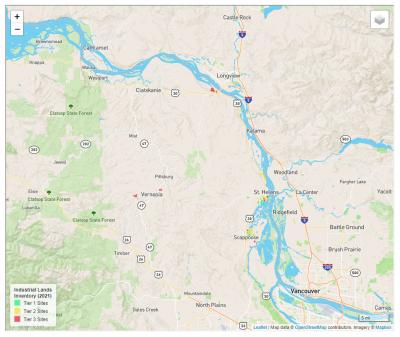
The study identified 33 available industrial parcels with five or more acres of net developable land, after accounting for wetlands, floodplain, and slope constraints. Of these, seven are identified as “tier one” or “shovel-ready” within six months.
All the tier one sites are in either Scappoose or St. Helens. Only two of the shovel-ready sites have more than 25 net developable acres to accommodate larger industrial users.
Twelve sites are classified as “tier two,” and require an estimated seven to 30 months and additional costs before being ready for development.
Fourteen sites are identified as “tier three,” requiring a significant financial investment before they would be development ready.
Both the cities of Rainier and Vernonia have zero tier one, “shovel-ready” sites available for immediate development. Rainier has half of the tier three sites, with seven total. Clatskanie has no industrial sites that met the inventory criteria.
Tier levels were based on the analysis of site use restrictions, annexation requirements, available utility infrastructure, transportation access, and whether the owner is willing to transact.
Data from the study was used to create an online, interactive mapping tool, accessible on the Port of Columbia County and Columbia Economic Team (CET) websites, along with a copy of the complete report and data tables.
“The port often gets inquiries from businesses that we don’t have a suitable site for. Now we can refer them to this online tool, where they can easily explore other available industrial properties in the county that may be able to meet their needs,” said Clark.
The Columbia County Industrial Land Inventory Project was guided by an advisory group made up of staff from the port, the cities of Scappoose and St. Helens, Columbia Economic Team, and Columbia River PUD.
The port received a $7,500 grant from the Columbia River PUD Economic Development Grant Program and $5,000 from Scappoose to assist in funding for the study.
###
About the Port of Columbia County
The Port of Columbia County is a special district located along the Columbia River in northwest Oregon. The port’s mission is to foster local economic development opportunities to create and sustain jobs while maintaining the environmental assets of the port district. The port offers a variety of sites for industrial lease and development in its 2,400-acre portfolio. More information at www.portofcolumbiacounty.org.

